- The Uttarakhand State Disaster Management Department (USDMA) will conduct a vulnerability study of 13 glacial lakes, five of which are in high-risk zones.
- The study aims to provide data to help prevent calamities such as lake outbursts.
- New lakes were identified through satellite imagery earlier this year.
- The high-risk lakes are located in the Darma, Lasaryanghati, and Kutiyangti Valleys in the Pithoragarh district, and Vasudhara Tal Lake in the Dhauli Ganga basin in Chamoli district.
GLOF (Glacial Lake Outburst Flood)
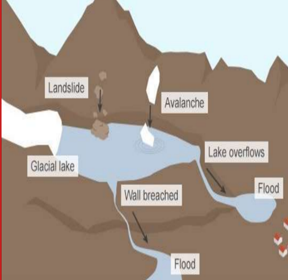
- A GLOF is a flood resulting from the sudden and rapid release of water from a glacial lake, often caused by the failure of a moraine dam or ice dam.
- The primary trigger for a GLOF is the collapse or breach of a moraine dam or ice dam holding back water. This can be caused by factors such as glacial melt water, avalanches, or volcanic activity.
- Glacial lakes are typically formed by the accumulation of meltwater from glaciers.
- These lakes range from 0.02 sq. km to 0.5 sq. km in area and are situated at elevations of 4,000 meters above sea level.
- USDMA teams will start a bathymetry study of these five potentially high-risk lakes to obtain accurate information.
- The Indo-Tibetan Border Police shared a report on the status of these lakes.
- After assessing the risk, the lakes will be punctured and pipes placed inside them to manage water levels.
- Experts from the Indian Institute of Remote Sensing, the Geological Survey of India, the National Institute of Hydrology, Roorkee, the Centre for Development of Advanced Computing, and the Wadia Institute of Himalayan Geology were included in the study.
Bathymetry Study
- Bathymetry originally referred to measuring ocean depth relative to sea level, but it now encompasses the study of underwater terrain’s depths and shapes.
- Bathymetric Maps illustrate the underwater landscape.
- Variations in the underwater floor relief are shown using colours and contour lines known as depth contours or isobaths.
Dig Deeper: Read about the major glacial lake outburst floods of Uttarakhand like the Kedarnath Valley flood in June 2013 and the Rishiganga Valley flood of 2021 in Chamoli.