- The intense wildfires in the United States and Canada have generated pyrocumulonimbus clouds, which can produce thunder and spark more fires, with their frequency increasing from an average of 102 globally per year to 140 in Canada alone last year.
- Not all wildfire creates pyrocumulonimbus clouds. These clouds form only during extremely hot wildfires or volcanic eruptions. E.g. Australian bushfires of 2019-2020 when temperatures exceeded 800 degrees Celsius.
- The intense heat from the fire warms the surrounding air, causing it to rise into the atmosphere.
- As this hot air, carrying water vapour, smoke, and ash, rises, it expands and cools down.
- When cool enough, water vapour condenses on ash, forming a grey or brown pyrocumulus cloud, also known as a ‘fire cloud.’
- If sufficient water vapour is available and the upward movement of hot air intensifies, pyrocumulus clouds can evolve into pyrocumulonimbus clouds.
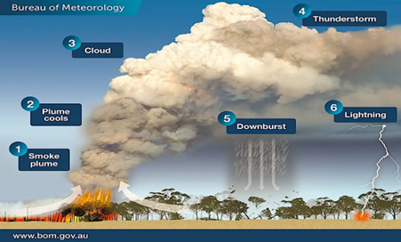
- These can reach heights of 50,000 feet and generate thunderstorms.
- Although pyrocumulonimbus clouds can produce lightning, they do not generate much rain, potentially sparking new wildfires many kilometres away from the main blaze.
- These clouds can also trigger strong winds, making wildfire spread faster and more unpredictable.
Dig Deeper: Read about the relationship between Climate Change and the increased frequency of generation of Pyrocumulonimbus Clouds.